This is a map from quite a while ago, 2014 in fact. This was one of the first times that a group of people really tried to gather together a good set of subject data that could be easily searched down to a very local level. It certainly did not try to cover everything, but it was a good source of information for its time. It even spawned a book.
The data sets used covered information from various sources, such as the Office for National Statistics (ONS), The Met Office, Public Health England to name a few. A full list of all the data sources used is available. The project, run by the Small Area Health Statistics Unit at Imperial College London, seems to have come to a close not long after the publication of the book. Time and data collection has really moved quickly over the subsequent 10 years, with Information/Statistics about every conceivable subject at the drop of a hat!

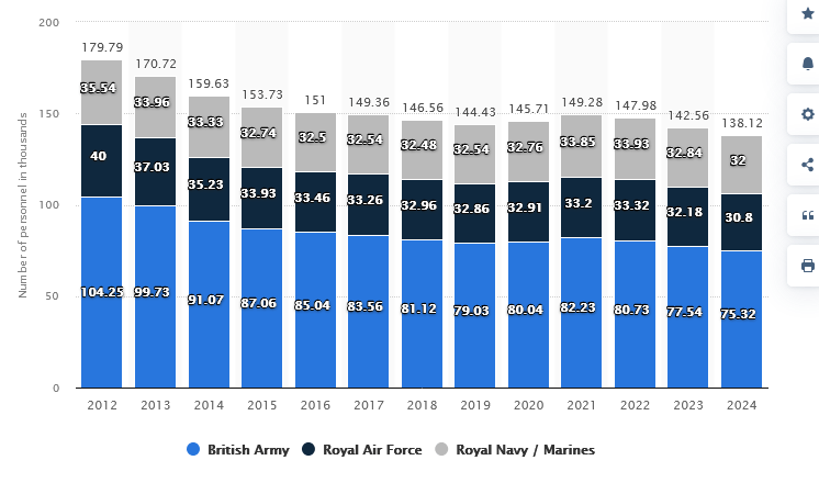
Defence spending is a big topic of conversation at the moment across the whole of Europe and with the next UK strategic defence review due in the Spring of 2025, it will be interesting to see how the UK.Gov intends to spend its scarce financial resources, given the recent comments by the US Trump administration.
Here’s a set of listings of how much various countries currently spend on Defence? Not a subject that is going away.

Britain From Above recently updated its pricing and added some more images to its archive. It’s a fascinating site where you can lose track of time looking through the various historical images.
There are now quite a few other historical aerial mapping sites to visit.
UK Aerial Photos, National Collection of Aerial Photography, Britain from the air: 1945-2009 and the Royal Air Force Museum to name a few.